序言

數千、萬年以前,是誰在這片土地上生活?考古學家如同偵探般揭開地底下的神秘面紗,透過對地層底下出土文化遺物、遺跡的抽絲剝繭,拼湊出史前人類善用自然資源、精於工藝、交流互換的豐富生活圖像,發掘出各地多元而精采的文化。國定考古遺址代表臺灣史前時代人類歷史的重要內涵,這些遺址埋藏著先民的生活與智慧,透過考古發掘及研究,讓人們更貼近這塊土地過去發生的事,現在就跟著我們一起探索這片土地曾經出現的豐美文化,一起解秘史前人類的生活故事吧!


Introduction

Others, who lived on this land ten thousand years ago? Archaeological experts speculate that the mystery of the underground will be revealed through reasoning, through the cocoon of the cultural relics and relics unearthed under the stratum, and put together large-scale life images of prehistoric humans using farms, skilled in crafts, and exchanges, and excavated richness. And a brilliant culture. Research, let people get closer to what happened in this land in the past, now follow us to explore the rich culture that once appeared in this land, and explain the life stories of prehistoric humans together!Others, who lived on this land ten thousand years ago? Archaeologists speculate that the mystery of the underground will be revealed through reasoning, through the cocoon of cultural relics and relics unearthed under the stratum, and put together large-scale life images of prehistoric people who used farms, crafts, exchanges and exchanges, and unearthed riches. And a brilliant culture.


認識十處國定考古遺址

Learning about the Ten National Archaeological Sites
 

國定鳳鼻頭(中坑門)考古遺址

年代 新石器時代(距今約5200~2000年)

文化內涵
鳳鼻頭考古遺址是古南島語族登陸地點之一,豐富的文化內涵,不僅在年代上橫跨整個新石器時代,包含「大坌坑文化」、「牛稠子文化鳳鼻頭類型」及「鳳鼻頭文化」3個文化層,呈現臺灣西南部的史前文化發展層序。大坌坑文化出土以夾細砂的繩紋陶罐及缽形器為主;牛稠子文化鳳鼻頭類型以細繩紋陶為主,生活方式主要為農業、狩獵和採集;鳳鼻頭文化層堆積較厚,文化遺物以紅褐素面夾砂陶為主,也出土加工獸骨、貝塚等自然遺物,可知陸域與海岸資源利用相當普遍。

參觀資訊:鳳山丘陵南端前緣緩坡處 (須向高雄市政府文化局提出申請才能前往)。

詳細資訊請參閱國家文化資產網


National Fengpitou(Zhongkengmen) Archaeological Site 

Era Neolithic Age (5200-2000 years ago)

Cltural Meaning
Fengpitou Archaeological Site is one of the landing spots of Austronesians. The culture was rich. The time span covers the whole Neolithic Age including three cultural beds of “Dapenkeng Culture”, “Fengpitou type of Niu Chou Zi Culture” and “Fengpitou Culture”. It shows the prehistoric cultural beds of southwestern Taiwan. Most of the unearthed objects of the Dapenkeng Culture are corded terrines and bowl-shaped objects of fine sand; Fengpitou type of the Niu Chou Zi Culture is based on fine corded ware. Life styles referred to agriculture, hunting and collection; Fengpitou cultural bed is thicker and the cultural relics mostly referred to reddish brown and plain sand pottery. There were natural relics of manufactured beast bones and shell mounds. It shows that the use of land and coastal resources was common. 

Visitor information: leading edge of gentle slope in the south of Feng Shan Hill (submit application to Bureau of Cultural Affairs, Kaohsiung City Government for visitor permits).

For more information refer to this link


國定萬山岩雕群考古遺址

年代 至今不明

文化內涵
全臺灣唯一的岩雕遺址,以尖器刻劃人形、蛇紋、蛙紋、同心圓紋等豐富的幾何形或具象紋樣,雕刻在可達八十餘平方公尺的巨石上。遺址藏身在深山密林中,自1978年首次被發現以來,已累積發現4處、14座具有刻紋的岩體,根據初步調查顯示部分紋樣與排灣族和魯凱族相關。四號岩雕大軋拉烏遺址的年代,推測主要集中在距今1262-926年左右,當時人們主要居住在遺址周邊的岩蔭內;至距今926-795年左右開始建造石板屋,並且在石板屋的底板也留下類似的幾何形圈點刻紋,直到距今520-318年左右,人群逐漸離開,石板屋因此遭到廢棄。

參觀資訊:茂林區原始林區(須向高雄市政府文化局提出申請才能前往)。

詳細資訊請參閱國家文化資產網


National Wanshan Rock Carvings Archaeological Site 

Era Remain unknown

Cltural Meaning
It is the only rock carving site in Taiwan. People at the time carved geometric or concrete patterns of human, snake, frog and concentric circles with sharp tools on the giant stone which has the size of over 80 square meters.The site is hidden in the mountain. Since the first discovery in 1978, 4 spots and 14 rocks with carved patterns have been found. According to primary investigation, part of the patterns might be associated with Paiwan and Rukai. The time of No. 4 rock sculpture Da Ga La Wu site was estimated to the period of 1262-926 years ago. At the time, people lived in the shelter of rock around the site. About 926-795 years ago, they started building slate houses and carved similar geometric and circular patterns at the bottom of slate houses. Around 520-318 years ago, people began leaving the place and the slate houses were abandoned.  

Visitor information: Primary forest area of Maolin area (submit application to Bureau of Cultural Affairs, Kaohsiung City Government for visitor permits).

For more information refer to this link


國定曲冰考古遺址

年代新石器時代(距今約3200-2300年)、金屬器時代(距今約1300-1000年)

文化內涵
曲冰考古遺址有二個文化層,年代自新石器時代中期至金屬器時代,可以完整敘說本區數千年來的史前文化發展史,在海拔約1,000公尺的高山地區是相當稀少的。本遺址出土大面積的完整聚落結構,其遺物與遺跡内涵豐富,包含至少48處房屋基址及171座石板棺墓葬,為迄今山區僅見的大型聚落考古遺址。早期房屋的主結構用板岩立柱,外牆基礎也以板岩支撐;晚期房屋不再以板岩作為主結構材料,但會將板岩平鋪於屋內地面。另外,出土的玉圓芯、廢料等製玉遺留,也顯示當地有製玉技術,推測應與東部同時期的人群移動有關。

參觀資訊: 仁愛鄉萬豐村境內河階上(自由參觀,但早期發掘現場須向中央研究院提出申請才能進入)。

詳細資訊請參閱國家文化資產網


National Chuping Archaeological Site 

Era Remain unknown

Cltural Meaning
It is the only rock carving site in Taiwan. People at the time carved geometric or concrete patterns of human, snake, frog and concentric circles with sharp tools on the giant stone which has the size of over 80 square meters.The site is hidden in the mountain. Since the first discovery in 1978, 4 spots and 14 rocks with carved patterns have been found. According to primary investigation, part of the patterns might be associated with Paiwan and Rukai. The time of No. 4 rock sculpture Da Ga La Wu site was estimated to the period of 1262-926 years ago. At the time, people lived in the shelter of rock around the site. About 926-795 years ago, they started building slate houses and carved similar geometric and circular patterns at the bottom of slate houses. Around 520-318 years ago, people began leaving the place and the slate houses were abandoned. 

Visitor information: Primary forest area of Maolin area (submit application to Bureau of Cultural Affairs, Kaohsiung City Government for visitor permits).

For more information refer to this link


國定大坌坑考古遺址

年代新石器時代(距今約6500-4200年)

文化內涵
大坌坑考古遺址為具有清晰多文化層疊壓的遺址,包括大坌坑文化、訊塘埔文化、圓山文化、植物園文化、十三行文化及近代漢文化等,且為辨認大坌坑文化的典型遺址,亦為研究臺灣新石器時代早期階段的重要考古遺址之一,在瞭解臺北地區史前文化層序演變上,佔有重要地位。考古遺址內出土大量中國宋、元朝代以來的陶瓷片,為瞭解當時臺灣與中國歷代,甚至東南亞一帶的交通與互動關係提供重要資料。對於研究臺灣與南島語系人群移動路線的關連具有特殊意義。

參觀資訊:觀音山西北側山麓緩坡周圍 (須向新北市立十三行博物館提出申請才能前往)

詳細資訊請參閱國家文化資產網


National Tapenkeng Archaeological Site 

Era Neolithic Age (6500-4200 years ago)

Cltural Meaning
Tapenkeng Archaeological Site is the one with specific multi-cultural beds, including the Dapenkeng Culture, the Xun Tang Pu Culture, the Yuanshan Culture, the Botanical Garden Culture, the Shihsanhang Culture, and modern Han culture. It is the typical site of the Dapenkeng Culture and one of the important archaeological sites in early research of the Neolithic Age in Taiwan. It plays an important role to approach the evolution of prehistoric cultural beds in Taipei area. In the archaeological site, great number of ceramic tiles from Song and Yuan Dynasties of China were unearthed which are important reference to explore the transportation and interaction between Taiwan and China in different dynasties and even Southeast Asia at the time. It is significant to study the correlation between Taiwan and the immigration routes of Austronesians. 

Visitor information: surrounding of gentle slope of the mountain at the northwest of Guan Yin Shan (submit application to New Taipei City Shihsanhang Museum of Archaeology for visitor permits)

For more information refer to this link


國定十三行考古遺址

年代 金屬器時代(距今約1800-500年)

文化內涵
十三行考古遺址位於淡水河南岸,為交通便利的濱海遺址,出土煉(鍛)鐵遺跡與大量鐵渣,是臺灣首次確認的冶鐵遺址,並是以臺灣北部金屬器時代文化(十三行文化)命名的遺址。文化層包含史前時代十三行文化層與歷史時期漢人文化層。從出土豐富的遺物與遺跡中,顯示自史前時代,本遺址已與島外有積極的互動,如金銀飾品、青銅器與玻璃、紅石髓珠飾品;另外,人形青銅刀柄、銅鈴、玻璃環,與臺灣原住民祖傳物相似,為臺灣原住民族溯源提供極具研究價值的資料。

參觀資訊:八里污水處理廠(須向新北市立十三行博物館提出申請才能前往)、周邊設有新北市立十三行博物館及新北考古公園(自由參觀)。

詳細資訊請參閱國家文化資產網


National Shihsanhang Archaeological Site 

Era Metal Age (1800-500 years ago)

Cltural Meaning
Shihsanhang Archaeological Site locates at the southern bank of Tamsui River and is the coastal transportation hub. Iron-smelting remains and great amount of iron slag were unearthed at the site. It is the first iron-smelting historic site recognized by Taiwan and the one named after Metal Age Culture of northern Taiwan (Shihsanhang Culture). Cultural beds include the Shihsanhang Culture bed of the prehistorical era and the Han Culture bed of historical period. According to abundant unearthed relics and remains, it shows that from prehistorical era, the interaction between the site and the places out of the island was frequent. There were gold and silver ornaments, bronze ware and glass and carnelian ornaments; in addition, there were human-shaped bronze knife handle, copper bell and glass ring which were similar to heirlooms of the indigenous peoples of Taiwan. Thus, it is important research reference to trace back the origin of the indigenous peoples in Taiwan. 

Visitor information:Pa Li Sewage Treatment Plant (submit application to New Taipei City Shihsanhang Museum of Archaeology for visitor permits) and the surrounding includes New Taipei City Shihsanhang Museum of Archaeology and Hsinbei Archaeological Park (open to the public).

For more information refer to this link


國定圓山考古遺址

年代 新石器時代(距今約4500-2000年)

文化內涵
臺北盆地曾經是座大湖泊,受到冰河結束的影響,海水由關渡附近開始流入盆地,形成多樣化的生態。之後湖水退卻,盆地部分成了沼澤地。當時人們有農業作物,也獵捕山豬、野鹿,加上水下生態豐富,進而撈取魚貝類食用。圓山考古遺址是臺灣考古工作初期研究的開端。本遺址至少包含先陶文化、大坌坑文化、訊塘埔文化、芝山岩文化、圓山文化、植物園文化及十三行文化。素負盛名的是貝塚堆積現象,圓山文化可說是代表臺灣北部最重要的新石器時代文化。

參觀資訊:臺北市原花博公園、自然景觀公園(原舊兒童樂園)(自由參觀) 

詳細資訊請參閱國家文化資產網


National Yuanshan Archaeological Site 

Era Neolithic Age (4500-2000 years ago)

Cltural Meaning
Taipei Basin has been a large lake. Due to the end of glacier, sea water flowed into the basin near Kuan Du and resulted in the ecological diversity. Afterwards, lake water faded away and part of the basin became swamp. At the time, people had crops and they hunted wild boars and deer. Moreover, resources under water were rich and they fished for fish and shells for food. Yuanshan Archaeological Site was the start of early archaeological research in Taiwan. The site includes the Pre-pottery Culture, the Dapenkeng Culture, the Xun Tang Pu Culture, the Chishanyan Culture, the Yuanshan Culture, the Botanical Garden Culture, and the Shihsanhang Culture. Accumulation of shell mounds was well-known. Yuanshan Culture is the most important Neolithic Age culture in northern Taiwan. 

Visitor information: Old Taipei Expo Park and Natural Scenery Park of Taipei City (old Children’s Amusement Park) (open to the public)

For more information refer to this link


國定丸山考古遺址

年代 新石器時代(距今約3200-2300年)

文化內涵
丸山考古遺址為臺灣東北部第一個大面積發掘的新石器時代晚期遺址,文化層堆積達千餘年之久,出土遺物豐富多樣,展現出聚落長期發展的過程,是宜蘭新石器時代晚期的代表遺址。本遺址大量利用在地資源製作器物是丸山社會的一大特色,無論是石製或是陶製器物。另從玉器、特定陶器及大型石板的出土,顯示出丸山人與臺灣東部、北部及中央山脈區域人群的互動情形,清楚展現臺灣新石器時代晚期社會間的交換關係,是理解臺灣史前社會的重要遺址。

參觀資訊:冬山鄉丸山小丘(須向宜蘭縣政府文化局提出申請才能前往)。

詳細資訊請參閱國家文化資產網


National Wanshan Archaeological Site 

Era Neolithic Age (3200-2300 years ago)

Cltural Meaning
Wanshan Archaeological Site is the first cultural heritage site of the late Neolithic Age discovered in large scale in northeastern Taiwan. The accumulation of cultural beds has been more than one thousand years. The unearthed relics were diverse and they showed long-term development of the community. It is the representative site of the late Neolithic Age in Yilan. On the site, people at the time created utensils significantly by local resources and it was one of the features of Wanshan society, including stone or ceramic utensils. In addition, the unearthed jade objects, specific pottery and large slate show the interaction between Wanshan people and those in eastern Taiwan, northern Taiwan and Central Mountain Range. It specifically reveals the exchange among the societies in the late Neolithic Age in Taiwan. It is an important cultural heritage site to approach prehistoric societies of Taiwan. 

Visitor information: Wanshan hill of Dongshan Township (submit application to Bureau of Cultural Affairs, Yilan County Government for visitor permits).

For more information refer to this link


國定八仙洞考古遺址

年代 舊石器時代(距今約30,000-15,000年前)、先陶時代(距今約6,000-4,800年前)、新石器時代中期(距今約4700-4500年前)、新石器時代晚期(距今約3,500-2,000多年前)、金屬器時代(距今約2000年前之後)、近現代(距今約100年前後)

文化內涵
八仙洞考古遺址為臺灣最古老的史前遺址,年代可追溯到30,000年前的舊石器時代,是長濱文化的代表遺址,也是臺灣少見的洞穴遺址。當時的人類以採集、狩獵活動維生,並以天然的洞穴與岩蔭,依山面海而居成為一大特色。本遺址呈現了臺灣最早人群進住的證據,對臺灣的歷史具有重大意義。除了舊石器時代的發現外,八仙洞更是一處具有先陶時代、新石器時代中期及晚期、金屬器時代以及近現代考古發現的遺址,年代跨距悠久,為具有多文化層的重要考古遺址。

參觀資訊:東部海岸國家風景區/八仙洞遊憩區(自由參觀)

詳細資訊請參閱國家文化資產網


National Pahsientung Archaeological Site 

Era Paleolithic Age (30,000-15,000 years ago), Pre-Pottery Age (6,000-4,800 years ago), Mid-Neolithic Age (4700-4500 years ago), Late-Neolithic Age (3,500-2,000 years ago), Metal Age (2000 years ago), Modern Age (100 years ago)

Cltural Meaning
Pahsientung Archaeological Site is the most ancient prehistoric site in Taiwan and it can be traced back to the Paleolithic Age 30,000 years ago. It is the representative site of the Changbin Culture and the rare cave site in Taiwan. At the time, human beings made a living by collection and hunting. They lived in natural caves and the shelters of rock, facing the sea by the mountain. The site shows the earliest human residence in Taiwan and it is significant in the history of Taiwan. Besides the findings of the Paleolithic Age, Pahsientung Archaeological Site is the one with archaeological findings from the Pre-Pottery Age, the mid- and late-Neolithic Age, the Metal Age, and the Modern Age. The span of time for this site is long and it is an important archaeological site of multi-cultural beds. 

Visitor information: East Coast National Scenic Area / Pahsientung Archaeological Site (open to the public)

For more information refer to this link


國定卑南考古遺址

年代 新石器時代(距今約5300-2300年前)

文化內涵
卑南考古遺址為臺灣新石器時代晚期的大型聚落遺址,出土超過2,400具石板棺墓葬以及包括陶器與玉器的豐富陪葬品。該遺址已有完善的稻作農業,在生活與文化上也較舊石器時代提升許多。相似度高的家屋以東北-西南向並排比鄰而居,石板棺墓葬也以相同方向呈帶狀分布。從石板棺出土的陪葬品,可以瞭解當時的人很重視以玉器作為裝飾品的風俗,其中「人獸形玉玦」以及「玉管」是極具代表性的物件,都是臺灣最早被指定為國寶的史前出土遺物。

參觀資訊:卑南遺址公園(自由參觀)。

詳細資訊請參閱國家文化資產網


National Peinan Archaeological Site 

Era Neolithic Age (5300-2300 years ago)

Cltural Meaning
Peinan Archaeological Site is a large-scale settlement site in the late Neolithic Age of Taiwan. More than 2,400 stone coffins and mortuary objects such as pottery and jade articles were excavated. On the site, complete rice agriculture has existed and lives and culture were more advanced than the Paleolithic Age. Similar houses stand side by side in northeastern and southwestern directions. Stone coffins are distributed in belt in the same directions. Unearthed mortuary objects from stone coffins show the important custom to treat jade articles as decoration. Among others, “human beast shaped jade” and “jade tube” are representative objects and they are the earliest prehistoric unearthed objects designated as national treasures in Taiwan. 

Visitor information: Peinan Cultural Park (open to the public).

For more information refer to this link


國定Blihun漢本考古遺址

年代 金屬器時代(距今約1800-900年)

文化內涵
漢本考古遺址發現完整度極高的聚落型態,具有大規模的駁坎、火塘、煉鐵爐及石棺群等史前遺跡,出土金箔、人面青銅刀柄及骨雕等重要標本。漢本考古遺址是新石器時代轉變為金屬器時代的代表遺址,外來的金屬器、高溫技術及瑪瑙,取代原產的玉器,成為臺灣史前人類的重要裝飾與儀式用品,延續至當代成為原住民物質文化的重要元素,其發現在學術史上佔有重要意義。本遺址以海域為重要交通動線,充分顯示早期人群的海洋文化特色,對於當今以海洋立國的臺灣而言,具特殊啟示意義。

參觀資訊:蘇花改公路漢本段(現場不適合參觀)。

詳細資訊請參閱國家文化資產網


National Blihun Hanben Archaeological Site 

Era Metal Age (1800-900 years ago)

Cltural Meaning
At Blihun Hanben Archaeological Site, its settlement pattern was discovered to remain in very good physical condition and there were large-scale prehistoric remains such as embankment, hearths, ironmaking furnace and stone coffins. Important specimen such as gold foil, human face bronze knife handle and bone carving were unearthed.Blihun Hanben Archaeological Site is the representative spot from the Neolithic Age to the Metal Age. Foreign metal objects, high temperature technique and agate replaced the original jade articles and became important ornaments and ritual articles for human beings in prehistoric era of Taiwan. They further turned into important elements of indigenous material culture in modern time. This discovery is significant in the modern academic history.Transportation on the sea appeared to be an important traffic circulation for this site. It shows the marine culture of people in early times and is significant for modern Taiwan which relies on ocean. 

Visitor information: Suhua Improvement Highway Hanben section (not open to visitors).

For more information refer to this link


交通樞紐上的漢本

1.清領以來的東臺灣有「後山」之稱,原因之一是對外陸路交通不便,尤其宜蘭和花蓮之間在山崖天險阻絕下,往來更是困難。
2.19世紀末,為改善交通,清廷闢築翻山越嶺的軍用步道;日治時期改築為單線通行汽車的臨海道;戰後逐步修繕拓寬為風景壯麗的蘇花公路,加以北迴鐵路完工,大幅增進花蓮的對外交通;臺九線蘇花公路改善計畫則以長型隧道,提升道路安全性。
3.然而在陸路交通之前,居住在漢本的人群如何行進於蘇花之間?從Blihun漢本考古遺址的發掘,證實臺灣北部和東部之間,在1000多年前已密切往來,當時的人群可能利用海域做為交通動線。
4.漢本位處舟車之利,從史前至今,一直是一處海陸交通上重要的樞紐。


Blihun Hanben in Transportation Hub

1. Since the Qing ruling period, eastern Taiwan has been called “Back Mountain”. One of the reasons is that the external access was inconvenient, particularly the section between Yilan and Hualien separated by cliffs and dangerous terrains.
2. At the end of the 19th century, in order to improve the traffic, the Qing court constructed the military trail in the mountains; in the Japanese Occupation Period, it established Coastal Road with one-way traffic; after the war, it was successively expanded as Suhua Highway with an impressive view. With the accomplishment of North-link Line, it significantly enhanced the external access of Hualien; Suhua Highway Improvement Plan of Taiwan Nine Road strengthened the security of roads by long tunnels.
3. However, before the land traffic, how did the people living in Hanben access Suhua? The excavation of Blihun Hanben Archaeological Site shows the frequent interaction between northern and eastern Taiwan more than 1000 years ago. People at the time might treat the sea area as a traffic line.
4. With the convenience of transportation, from the prehistoric period to the present, Hanben has been the important hub of sea and land transportation.


聚落的形成

「Blihun」與「漢本」
「漢本」及周邊的舊名以泰雅族語發音為「Blihun」,有「門戶」之意,漢字寫為「白來分」或「白里分」。日治1924年的《臺灣地圖》中,可見大濁水溪(今和平溪)北岸,以日文標記「ぺレフン」(Blihun)(約今「谷風」位置);今日海巡署「白來分安檢所」亦以舊稱為名。1980年2月1日北迴鐵路通車,因設置漢本火車站,「漢本」之名才廣為使用。2016年8月15日,文化部以「Blihun漢本」之名公告國定遺址。2017年11月17日,文化部重新公告其為國定考古遺址。

和平溪北岸的聚落
從蘇澳到花蓮崇德,西倚中央山脈、東臨太平洋,驚險褊狹的懸崖地形難有可居之地,惟有在河流堆積作用的開闊土地上,可望成為崖壁邊的聚居地。Blihun漢本考古遺址位於宜、花縣界的和平溪出海口北岸山腰緩坡,1千多年以前,人類在此聚居,發展出豐富的文化內涵。


舟車之利

海上交通的據點(史前時代 )
清治《後山輿圖》稱蘇澳到崇德間「峭壁崚嶒,難通輿馬」,但由Blihun漢本考古遺址出土的文物來看,當時不僅具有發達的海路交通,另外可能經由和平溪谷而與內陸存在密切往來。

石亀碉:蘇花古道上的軍事營址(清治時期 )
宜蘭與花蓮的陸路交通,自古因天險危崖而少人行,1874年牡丹社事件後,清廷為駐防鎮壓,於蘇澳以南至花蓮,開闢僅供步行的「後山北路」(約今蘇花古道),沿途紮營屯兵,其中石亀碉與Blihun漢本考古遺址區位相近。後山北路因地形起伏大,加以施工快速簡陋,路基多已不存。

白來分駐在所:蘇花臨海道上的汽車休憩所(日治時期)
為取得東臺灣自然資源及制撫原住民族,1925年完築「東海徒步道」,1932年續修為單向通車、以壯麗絕壁著稱的「蘇花臨海道」(今蘇花公路前身),汽車運輸開始進入東臺灣。從《東海巴士路線案內圖》(1935),可知白來分距蘇澳35.2哩(約56公里),距花蓮港40.4哩(約64公里),因位於臨海道中繼點而成為休憩所。

漢本車站:蘇花公路與北迴鐵路的中間站(戰後至2010年)
戰後持續改善並拓寬蘇花臨海道,1990年10月25日解除單向管制,成為可雙向通行的蘇花公路。1973年12月25日,十大建設中的北迴鐵路動工,1980年2月1日通車,鐵路成為花蓮對外的重要交通方式,漢本車站為蘇花公路與北迴鐵路併行的宜花中間站,也是進出花蓮的門戶。

Blihun漢本考古遺址:蘇花公路改善計畫的大發現(2010年至今)
因蘇花公路彎曲且落石頻傳,也為回應「安全回家的路」訴求,2010年通過蘇花公路改善計畫(簡稱「蘇花改」)、2011年動工、2020年1月6日通車,東臺灣對外交通更為便捷。2012年於蘇花改谷風隧道南口發現史前遺留,隨後進行搶救發掘,因具完整文化層與內涵,2016年指定為國定遺址。

 
Blihun Hanben in Transportation Hub

Formation of settlements

“Blihun” and “Hanben”
The old name of “Hanben” and the surrounding being named as “Blihun” in the Atayal language have the meaning of “gateway”. In Chinese characters, it is “Bailaifen”. In Taiwan Map of 1924 during the Japanese Occupation Period, “Blihun” (“Gu Feng” of nowadays) was marked in Japanese on the north bank of Dajhuoshuei River (Heping River of nowadays); it is the origin of the name for the present Coast Guard Administration “Bailaifen Inspection Office”. On February 1, 1980, North-link Line was launched. “Hanben” was widely used after the construction of Hanben Station. On August 15, 2016, Ministry of Culture announced national relics by the name “Blihun Hanben”. On November 17, 2017, Ministry of Culture released the announcement as the national archaeological site.

Settlements on the north bank of Heping River
From Suao to Zhong De of Hualien, it was Central Range in the west and the Pacific Ocean in the east. It was hardly habitable due to the dangerous cliffs. The settlements were constructed along the escarpment on the open space accumulated by river. Blihun Hanben Archaeological Site is at the gentle slope of the north bank of the mouth of Heping River at the border of Yilan and Hualien. More than one thousand years ago, human beings constructed the settlements and developed abundant cultural content.


Convenience of transportation

Transport hub on the sea (prehistoric period)
According to Map of Back Mountain in the Qing ruling period, there were “cliffs and the transportation was inconvenient” between Suao and Zhong De. However, according to the unearthed relics of Blihun Hanben Archaeological site, at the time, sea transportation was advanced. In addition, there could be frequent land interaction through Heping River Valley.

Shigui Fort: the military site on Suhua Ancient Trail (Qing ruling period)
Land route transportation between Yilan and Hualien has been difficult due to the dangerous cliffs since ancient time. After the Mutan Village Incident in 1874, for the concern of garrison and suppression, from the south of Suao to Hualien, the Qing court developed “Back Mountain North Road” (Suhua Ancient Trail of nowadays) only for walking and station troops along the way.Shigui Fort was near Blihun Hanben Archaeological Site. Due to severe undulating terrain of Back Mountain North Road and rapid and simple construction, most of the roadbeds no longer existed.

Bailaifen Police Post: the vehicle rest stop along Suhua Coastal Road (Japanese Occupation Period)
In order to obtain natural resources of eastern Taiwan and govern the aboriginals, in 1925, it constructed “Tunghai Trail” and in 1932, the reconstruction was one-way traffic. “Suhua Coastal Road” (the former of Suhua Highway) was well-known by the impressive cliffs and automobile transportation was introduced in eastern Taiwan. According to Timetable of Tunghai Bus Routes (1935), the distance between Bailaifen and Suao was 35.2 miles (around 56 km). The distance between Bailaifen and Hualien harbor was 40.4 miles (around 64 km). It became rest stop since it was the middle point of Coastal Road.

Hanben Station: the station between Suhua Highway and North-link Line (post-war to 2010)
After the war, the improvement continued and Suhua Coastal Road was expanded. On October 25, 1990, Suhua Highway was evolved from single-way control to two-way traffic.On December 25, 1973, the construction of North-link Line in Ten Major Construction Projects was launched and the line was open to traffic on February 1, 1980. Railway became the important external access of Hualien. Hanben Station was the middle stop of Suhua Highway and North-link Line and the gateway to access Hualien.

Blihun Hanben Archaeological Site: the major discovery during the Suhua Highway Improvement Plan (2010 to present)
Since Suhua Highway was winding and there were frequent falling stones and to respond to the appeal “drive home safely”, in 2010, Suhua Highway Improvement Plan (“Suhua Gai” for short) was passed and the construction began in 2011. Due to this highway’s opening to traffic on January 6, 2020. external transportation of eastern Taiwan becomes more convenient. In 2012, prehistoric remains were discovered at the south exit of Gu Feng Tunnel of Suhua Gai, followed by the rescue and excavation. With complete cultural layers and content, in 2016, it was designated as national relics.


Blihun 漢本考古遺址發掘

發現Blihun漢本考古遺址

考古遺址發現與搶救
考古遺址無法複製及遷移,一旦擾動就會完全破壞原有的空間脈絡,只剩考古標本價值,因此遺址以原地保存為佳。在無法原地保存之情形下,縮小開發範圍,並透過發掘、搶救、移置開發區內的遺物成為折衷之道。2011年動工的蘇花公路改善工程是全國矚目的重大工程,動工前歷經多次環境影響評估,施工時依文化資產保存法進行施工監看。2012年3月5日監看單位在谷風隧道南口發現疑似史前文化遺留,自此開始一連串的文物搶救及文化保存運動。2017年9月25日蘇花改工程範圍內的文物搶救發掘完成,並遷移他處。


掘過程與紀錄

2012~2016 重見漢本
2012.03.05 蘇花改谷風隧道南口附近之臨時滯洪沉砂池及邊坡發現有史前遺留,同日下午16:00通知並填報「監測成果超標管理通報單」,同時建議停工。
2012.03.06 確認為文化遺留出土地點,工程須暫時停工,並劃定附近區域為文化遺址敏感區域,進行坡面安全措施保護,發函宜蘭縣政府文化局依文化資產保存法及環境影響評估承諾進行通報。
2012.03.15 宜蘭縣政府文化局會勘後決議以搶救發掘方式處理。
2012.09.15 中央研究院歷史語言研究所考古團隊開始進行搶救。
2016.03.28 指定為縣定遺址。
2016.03.28 庶古文創事業股份有限公司加入發掘搶救工作。
2016.05.21 P3N橋墩基礎範圍發現完整之石砌遺構現象。
2016.08.15 指定為第8處國定遺址。

2016~2017 重建漢本
2016.09.26文化部文化資產局決議石砌遺構現象採現地保留、掃瞄記錄、異地展示方式處理;工程單位變更橋墩設計,提高基礎底部高程。
2016.11.17 石砌遺構現象開始進行數位掃瞄、外範複製。
2017.02.25 完成外範複製作業。
2017.03.11 拆範並進行現象複製工作。

2017~至今 重現漢本
2017.08.10-11.21 於蘭陽博物館辦理「重見/建/現漢本Blihun-發掘階段成果特展」。
2017.09.25 完成遺址搶救發掘工作。
2017.11.17 重新公告類別為國定考古遺址。
2021.07.26-11.28 於文化部文化資產園區辦理「Blihun漢本-交通樞紐上的國定考古遺址展」。


指定「國定Blihun漢本考古遺址」

1.2016.08.15文化部指定公告為全國第8處國定遺址

2.2017.11.17 文化部重新公告類別名稱為「考古遺址」

3.指定範圍
位於宜蘭縣南澳鄉澳花村,漢本車站以南至和平溪北岸,東鄰太平洋,西倚濁水山山腳。面積約88,900㎡。

4.指定理由
考古遺址在文化發展脈絡中之定位及意義性:
已發現三大史前文化層,其文化內涵及重要性足以比擬國定十三行考古遺址。

考古遺址在學術研究史上意義性:
可解釋臺灣新石器時代晚期發展至金屬器時代之變遷。輸入外來之金屬器、高溫技術、瑪瑙,取代原產之玉器,成為臺灣史前人類重要裝飾與儀式用品,逐漸延續至當代原住民物質文化最重要組成的部分,其發現無疑在學術史上佔有重要意義。

考古遺址文化堆積內涵之特殊性及豐富性:
文化層堆積連續1,000年以上,除一般常見之陶石器外,更發現豐富之金屬器、玻璃、瑪瑙等外來物質,最重要的發現是完整度極高的聚落型態,依目前發掘結果已足以與國定卑南考古遺址比擬。

同類型考古遺址數量之稀有性:
文化內涵可充分詮釋新石器時代晚期發展至金屬器時代之過程,其稀有性如配合淇武蘭、利澤簡、海岸等考古遺址之所見,可完整顯示新石器時代晚期至文字時期前後之噶瑪蘭族之發展歷程。

考古遺址保存狀況之完整性:
文化層原埋封於1,000年左右之土石流地層下,保存狀況良好。與工程重疊部分採搶救發掘後,保留考古遺址總面積約94%,相較於因八里污水廠破壞後,僅保存總面積約5%之國定十三行考古遺址,及文化層最豐富部分受鐵路工程破壞之國定卑南考古遺址, Blihun漢本考古遺址保存狀況可謂較佳。

考古遺址供展示教育規劃之適當性:
位於鐵公路之樞紐地帶,未來自和平交流道進入考古遺址之路線亦相當便捷;所在地可充分詮釋人類與自然環境共處關係之省思,深具展示教育意義。

具其他考古遺址價值者:
自出土之文化、生態遺物及聚落相對位置,可說明遺址當以海域為重要交通動線,充分顯示早期人群之海洋文化特色,對於當今以海洋立國的臺灣而言,具特殊啟示意義。出土遺物顯見與當代原住民族–阿美族、撒奇萊雅族、蘭陽平原噶瑪蘭族、北海岸巴賽族、凱達格蘭族均有豐富關聯性,該考古遺址為這些人群傳說中祖先來源的重要方向,具非常重要的歷史意義。

資料來源:文化部國家文化資產網。

 
The Archaeological Excavation of Blihun Hanben Archaeological Site

Discovery of the Blihun Hanben Archaeological Site
Discovery and rescue of archaeological site
Archaeological sites cannot be reproduced and moved as both of these actions will completely destroy the original space; and once destroyed, the only value remained is archaeological samples. Therefore, it is favorable to maintain the original site. When preservation of the original site is impossible, compromise should be made by reducing the development scope and moving the relics by excavation and rescue.

Construction of the Suhua Highway Improvement Plan began in 2011 and was an important national project. Before the construction, there were several times of environmental assessments. The construction was monitored according to the Cultural Heritage Preservation Act.On March 5, 2012, the monitoring unit discovered the suspected prehistoric culture remains at the south exit of Gu Feng Tunnel and since then, there were a series of relics rescue and cultural preservation movements.On September 25, 2017, rescue and excavation of the relics in the construction scope of the Suhua Improvement Project were accomplished and the relics were moved to other places.


Excavation process and records
2012-2016 Re-presentation of Hanben
2012.03.05 Prehistoric remains were discovered at temporary detention basin and side slope near the south exit of Gu Feng Tunnel of Suhua Gai. It was reported at 16: 00 PM on the same day and “report of monitoring result exceeding the standards” was filled. The construction was suggested to be halted.
2012.03.06 Unearthed site of cultural remains was confirmed and the construction should be halted temporarily and the surrounding was designated as the sensitive area of cultural site for the concern of slope security. It was reported by mail to Cultural Affairs Bureau of Yilan County according to the Cultural Heritage Preservation Act and Environmental Impact Assessment.
2012.03.15 Resolution after a joint inspection of Cultural Affairs Bureau of Yilan County referred to rescue and excavation.
2012.09.15 Rescue was launched by the archaeological team of Institute of History and Philology, Academia Sinica.
2016.03.28 Designated as the site of the country.
2016.03.28 Archaeo Cultures participated in the excavation and rescue.
2016.05.21 Complete stone remains structure was discovered at the basic scope of the bridge pier P3N.
2016.08.15 Designated as the eighth national site.

2016~2017 Reconstruction of Hanben
2016.09.26 According to the resolution of Bureau of Cultural Heritage, MOC, stone remains structure was preserved on-site with scanned  records and exhibition in different places; the bridge pier construction unit changed the design and increased the height of the foundation.
2016.11.17 Digital scanning and external reproduction model of stone remains structure.
2017.02.25 Accomplishment of external reproduction model.
2017.03.11 Model taken apart and phenomenon reproduction.

2017~present Re-presentation of Hanben
2017.08.10-11.21 “Special exhibition of phase results of excavation: Re-presentation/reconstruction of Hanben Blihun” held in Lanyang Museum.
2017.09.25 Accomplishment of site rescue and excavation.
2017.11.17 Announcement of the national archaeological site.
2021.07.26-11.28 “Exhibition of Blihun Hanben-the National Archaeological Site Sitting in Transportation Hub” was held in Cultural Heritage Park, Ministry of Culture.


Designated “National Blihun Hanben Archaeological Site”

1. 2016.08.15 Ministry of Culture designated and announced it as the eighth national site

2. 2017.11.17 Ministry of Culture announced the “archaeological site”

3. Designated scope
It is located in O Hua Village of Nan O Township, Yilan County, from the south of Hanben Station to the north bank of Heping River. There was Pacific Ocean in the east and it was at the bottom of Mount Jhuoshuei to the west. The square measure is around 88,900 m2.

4. Reasons of designation
Position and significance of the archaeological site in the cultural development:
Three major prehistoric cultural layers have been discovered. The cultural content and importance can be compared to the national Shihsanhang archaeological site.

Significance of archaeological site in academic research history:
It can explain the evolution from late Neolithic Age to Metal Age. Foreign metalware, high-temperature technology and agate replaced the original jade articles and became important ornaments and articles of rituals of prehistoric human beings in Taiwan. Nowadays, they become important elements of indigenous material culture. The discovery is significant in academic history.

Uniqueness and richness of cultural accumulation of the archaeological site:
The accumulation of cultural layers is more than 1,000 years. Besides common ceramic and stone articles, there are abundant external materials such as metalware, glass and agate. The most important discovery was the highly complete settlements. The present result of the excavation can be compared with national Bei Nan archaeological site.

Preciousness according to the quantity of archaeological site of the same type:
The cultural content can fully interpret the development process from late Neolithic Age to Metal Age. As to the preciousness, according to archaeological sites such as Qi Wu Lan, Li Ze Jian and the coast, it completely shows the development of Kebalan from late Neolithic Age to around the period of characters.

Complete preservation of archaeological site:
Cultural layers were originally covered under the stratum of mudflows around 1,000 years ago and they were properly preserved. After rescue and excavation on the overlapping scope with the construction, it preserved around 94% of the total square measure of the archaeological site. In comparison to the national Shihsanhang archaeological site with only 5% of the total square measure preserved after being destroyed by Ba Li Sewage Treatment Plant and the national Bei Nan archaeological site with the most abundant cultural layers destroyed by railway construction, Blihun Hanben archaeological site showed more significant preservation.

Legitimacy of the archaeological site to serve for exhibition and educational planning:
It is located at the transportation hub of railway and highway. In the future, the route from Heping Interchange to the archaeological site is accessible; the site fully interprets the cohabitation between human beings and the natural environment and it reveals the educational significance of exhibition.

Value as other archaeological sites:
According to the relative locations of unearthed culture, ecological relics and settlements, the site relied on the sea area as an important traffic line. It reveals the marine culture of the people in early times and it is significant for modern Taiwan which relies on the ocean. The unearthed relics show a significant connection with modern indigenous peoples, Amis, Sakizaya, Kebalan of Yilan Plain, Basay of northern coast and Ketagalan. The archaeological site reveals extremely significant historic significance for the origins of ancestors in their legends.

Source: National Cultural Heritage Database Management System of Ministry of Culture.


Blihun漢本考古遺址發掘成果

島內互動
17世紀荷西文獻提及,北海岸馬賽人自蘇花海岸使用相同語言的哆囉滿人手中交易取得產自當地之黃金。語言學家也將馬賽語、哆囉滿語、噶瑪蘭語等都納在凱達格蘭語系之下。在傳說方面,臺灣北部、東北部及東部等不同族群的村落中,流傳著一則相同的傳說,傳說中都提到Sanasai這個島名。這些村落祖先或是從此出發、或是以此為中介,分別前往臺灣東海岸某處登陸或定居。跨族群流傳的傳說反映族群間的高度互動性。無獨有偶地在考古遺留中,以拍印紋為特色的十三行文化分布範圍大致與凱達格文化語系相符。另外也可以看到相同器物或是相似的型制、風格在北海岸及東部地區流傳。這一現象反映當時這一地區頻繁的交換及互動的關係。

島外互動
受到東亞及南亞季節性週期變換風向的季風所影響,南海及印度洋沿岸很早就發展出風帆式海上交換脈絡,隨著印度、波斯、阿拉伯文明的興起,海上絲路逐漸成形。至少自鐵器時代開始或更早,臺灣與菲律賓也被納入海上絲路而成為節點。

物質文化
生態資源
Blihun漢本考古遺址所處之蘇花斷層海岸為菲律賓海板塊隱沒入太平洋板塊擠壓後所形成,背倚陡峭筆直危崖,面向浩瀚無際大洋,看似窮山惡水,實則資源豐饒。

海域資源
蘇花一帶海底地形與陸域相同,地勢陡降,海岸線不遠處即下降至海水面下數千公尺。沿岸除立霧溪、和平溪口沖積扇外,幾無平緩的潮間帶,但外海不遠即為黑潮所流經,並因地形於北方形成湧升流,富涵營養鹽的海水被帶至上層,帶來大量的迴遊性魚類及尾隨而來的中大型掠食性魚種。

陸域資源
動物
蘇花一帶山勢陡峭,且面迎東北季風,森林茂密,是臺灣少數生態最多樣性之區域,而史前時代資源應該更為豐富。
岩石、礦物
遺址地處臺灣最古老的大南澳片岩帶上,早在三億年前即已形成堆積,後續多次的構造運動造就出多樣而高度變質的石材,主要有片岩、片麻岩、大理岩及各類變質火成岩等,這些石材常帶有含鐵礦物。另外岩層間的裂縫則因火成作用而充填成含金的礦脈。這些岩石、礦物隨著河流攜至河口而為先民所取用。

生計
種類
遺址所在少有平坦地形,植物性遺留也不常見。但動物資源相對豐富。海洋資源中,貝類以淺海性為主,如硨磲、夜光蠑螺、芋螺、寶螺等,數量不多。相對而言,魚類遺留則相當豐富。當時捕捉的多為中大型而活動敏捷的魚類,其中以鬼頭刀數量最多,其次如灰鯖鮫、旗魚、劍旗魚、鯨豚等。
方法
遺址中出土骨質魚卡子、魚鈎以及鐵質的槍頭等,但幾乎不見網墜,顯示當時可能以繩釣、鏢射為主要漁法。

石器工藝
石材
由於漢本考古遺址恰好位於地層年代早、變質度高的地層上,俯首可得的皆是高度變質及多樣的石材,漢本先民在製作或使用時仍有其特殊的偏好,常見有片麻岩、結晶石灰岩、各類變質火成岩以及板岩等。
器類
雖然當時已使用金屬器,但仍有一些器具是以石材製成,如木工用的錛、鑿等,敲砸硬物的砍砸器等。
工具
有刃器:有閃玉石錛、板岩石劍等。漢本石劍的特色是劍身、劍格、劍柄一體成形。
錘形器:取用各類堅硬的變質岩來使用。一般多未加工即直接使用,少部分會在頂端、兩側琢製或磨製。
礪棒:數量最多,如板岩、硬頁岩或細粒變質砂岩,呈長條狀,頂端常穿一孔。
裝飾品

環:大理岩、板岩等質地,兩面敲琢貫穿後再修磨而成。
扁平圓盤:大理岩磨製而成,周邊穿有小孔,以便繫線懸掛。
石片:大理岩質地,鑲崁裝飾用。

骨貝角牙器工藝
種類
海、陸等動物資源不僅作為食物,其身上的硬組織也常依特殊的成分、外形等,而被加工利用作為工具或裝飾品。
器類

骨角器:除了用於捕魚用的魚卡子及魚鈎外,若干獸骨因其特殊形狀,只要略微加工,即為合適的工具,如偶蹄類的尺骨因近端有一凹窩,有利握持,遠端趨細,因此常被加工成尖器;另外偶蹄類癒合的掌蹠骨、鹿角等也常被加工成鑿形器或握柄。
貝器:貝殼外殼堅硬、內層光澤亮麗,常被加工作為飾品。Blihun漢本考古遺址常見硨磲、芋螺等加工而成的貝環以及各式裝飾用的貝片。
牙器:貝殼因外表特殊的珍珠光澤、牙齒則因外表光亮的珐瑯質,容易引人注視,因此常被作為飾件。其中做為飾件的牙齒多為獸類犬齒或鯊、鮫等掠食性魚類的利齒,隱含勇猛的象徵意義。

高溫工藝
原料
臺灣金屬礦物蘊藏量不多,其中黃金主要分布於基隆火山群及中央山脈板岩帶中,前者以金瓜石礦區最為著名,後者更早在十七世紀荷蘭文獻中即述及,蘇花海岸南端的立霧溪口,亦即所謂的「哆囉滿」也有產金。另外,北海岸火山體及大南澳片岩帶中的岩石常含有磁鐵礦礦體,之後母岩因侵蝕、風化而被溪流攜至河口及海濱,並經潮水淘選,便形成重砂富集。上述兩類礦物都可在Blihun漢本考古遺址一帶發現。臺灣銅礦多以化合物狀態存在,必須經過提煉才能取得,且臺灣也少見用來製作銅合金的其它礦物。但金屬可高溫熔融後再製,因此既有的銅器也是原料來源之一。遺址中出土的銅錢可能是製作銅器的原料之一。而玻璃同樣也可將交換得來的玻璃器重新熔融再製。

製作
金屬器的製作包含原料的提煉及成形兩個程序:
提煉 

除黃金因活性低而多以天然狀態存在外,其它金屬礦物多以化合物形態存在,必須經過提煉還原回元素形態。其中鐵料多採「塊煉法」。方法上是將氧化的鐵砂(磁鐵礦,Fe3O4)以木炭加熱至攝氏六、七百度時,不完全燃燒所產生的一氧化碳與含鐵氧化物產生還原反應,含鐵礦物釋出氧而與一氧化碳結合成二氧化碳,並留下海綿狀鐵塊。
成形

大部分金屬都有極佳的延展性,因此在固態時即可藉由錘打來塑形。遺址出土的金箔、鐵器多是以錘打加壓的方式製作,稱之為鍛造,其中鐵器在製作時仍需加熱以增加其延展性,因此同樣需要利用鍛爐加熱。另外也可將金屬加熱至熔點而成為液態,再澆灌入模具中,此即「鑄造」。遺址中出土的砂岩石範即是鑄造的實證。

種類
金器:金具延展性,光彩耀眼,因此被製成各種外形的扁箔片狀飾品,並在事先刻好的印模上,錘鍱出各式紋樣。
銅器:多以鑄造方式製成。見有青銅刀柄、各式銅鈴等。
鐵器:鐵器多作為有刃工具或兵器,常見有片狀之刀、劍、矛、鏃等,末端或帶莖(鋌)、或為中空銎狀,可能是與骨柄、木柄等相接。另有尖狀之鈎、釘等。
玻璃器:主要作為飾品、包含鐲、耳飾、珠飾等。


精神文化

埋葬禮俗
葬地
漢本先民多將去世的親人埋葬在自己的屋內及前埕,相信死去親人的靈魂仍然存在於死者的遺骸內,而過世的親人仍是一家人,因此必須埋葬在自家的家域內。
葬室及葬具

夭折的嬰幼兒大多沒有使用葬具,其餘亡者常被置放在板岩拼組而成的葬室內。這些葬室或在室內成排排列,或埋設在室外前埕中。葬室可以重複使用,陸續埋葬死者,後期遺骸被埋葬時,會將早先被埋葬的遺骸移至一側以騰出空間。
葬式

大部分的亡者採側身屈肢葬,如同胎兒安詳蜷曲在母親的子宮內,可能象徵著再生。
陪葬品
亡者身上可能佩戴著各式飾品,身旁放置可能盛裝食物的陶罐或生前使用的工具。

具象藝術
臺灣約在距今3500年前左右的新石器時代中期起,即開始出現一些具象母題的物件。其中最著名的便是人獸形玉玦,另外還有獸形、獸首陶把以及併排人形玉飾等。至距今1800年左右開始進入金屬器時代,不僅具象母題出現的頻率愈來愈高,母題也更加多樣及複雜化,其中最常見為各式與人有關的母題。早期幾乎不見臉部各部位的刻劃,但至金屬器時代起,人面母題中,眼、耳、鼻、口等部位開始被勾勒出現。除此之外,動物母題也出現了蛇形等動物圖紋。
人面母題

具體的臉部輪廓在金屬器時代開始大量出現,Blihun漢本考古遺址上的青銅刀柄、骨質刀柄以及陶器上可見明確臉部輪廓的紋飾。
併排人形

早在新石器時代芝山岩考古遺址即已出現此一母題。Blihun漢本考古遺址刀柄石範上也見併排人頭母題。
蛇形紋

Blihun漢本考古遺址礪棒上可見刻劃出蛇形紋,相類似的紋飾在東海岸三和類型遺址,如舊香蘭也有發現。
獸偶

早在新石器時代開始出現,Blihun漢本考古遺址發現有板岩打剝的獸形剪影以及立體的動物陶偶。

身體裝飾
材質
新石器時代最常用來製作飾品的閃玉於此時幾乎銷聲匿跡,代之而起的是玻璃及金屬材質,包含玻璃手鐲、耳飾、珠飾、金箔、青銅鈴等。除此之外,貝飾、牙飾、骨角飾品仍持續被使用。產自當地的潔白大理岩也常被加工成為飾品,另外也有以島內板岩及島外玉髓製成之飾品。
種類
Blihun漢本考古遺址出土的飾品,不僅材質多樣,且種類繁複。包含佩戴於手臂的貝環、玻璃環、以板岩及大理岩製作的石環、作為耳飾的玻璃玦飾等。作為綴飾的材質、樣式相當多樣,包括有玻璃珠、大理岩珠、玉膸珠、玉管珠、青銅鈴、大理岩圓盤、貝珠、貝片等,由墓葬出土的脈絡來看,部分可能是縫綴於衣裳上。

 
Preliminary Results of the Archaeological Excavation of Blihun Hanben Archaeological Site

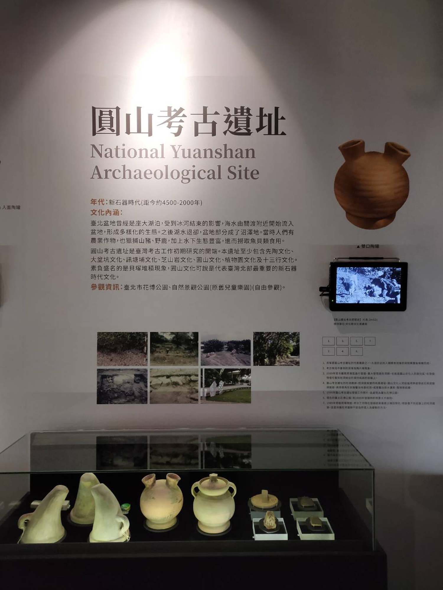
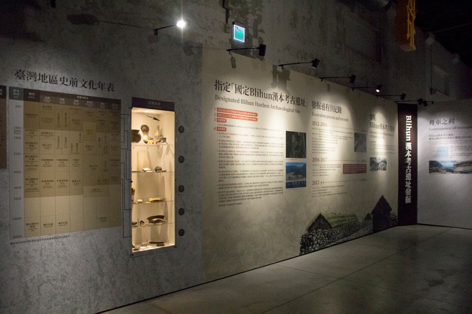
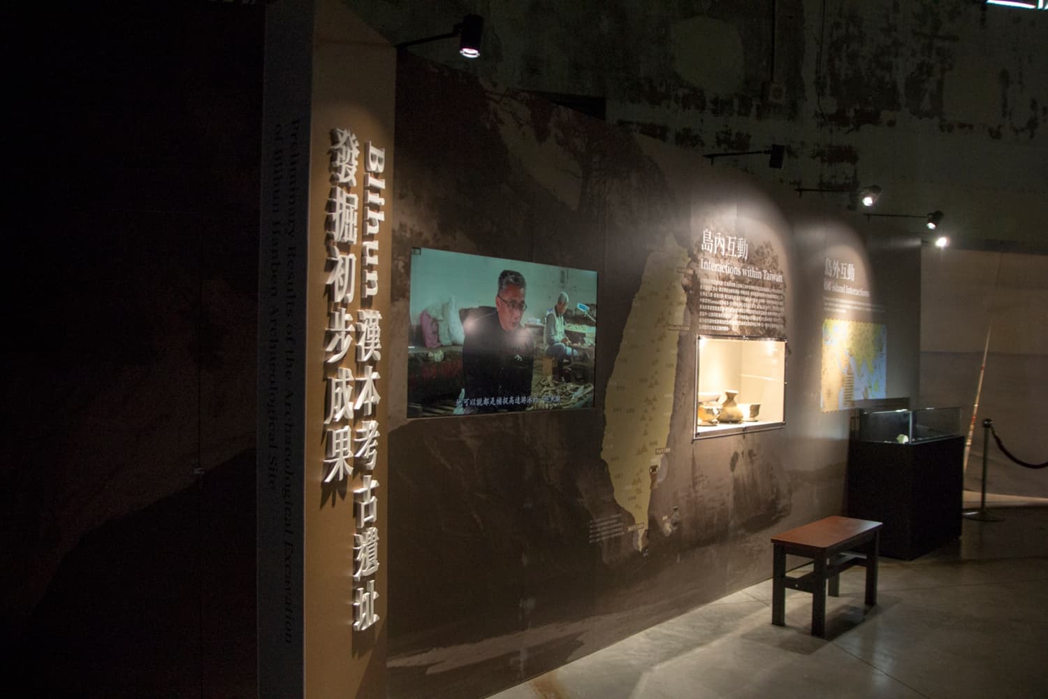
Interactions within Taiwan
In the 17th century, according to the Dutch and Spanish literatures, Basay of the northern coast obtained local gold by trading with Danau people using the same language at Suhua coast. The linguisticians categorized Basay language, Danau language and Kavalan in the Ketangalan language family. In addition, in different tribal villages of northern, northeastern and eastern Taiwan, they shared the same legend which mentioned the island, Sanasai. From the island, the ancestors of these villages landed on or settled in the eastern coast of Taiwan. The legend shared by different tribes shows their high degree of interaction. In addition, in archeological remains, the distribution scope of Shihsanhang culture featured by Pai Ying Pattern is generally consistent with Ketangalan culture language system. Furthermore, the same or similar utensils were shown in northern coast and eastern Taiwan, indicating the frequent exchange and interaction of the area at the time.

Off-island Interactions
Influenced by the monsoon which changes the wind directions seasonally in East and South Asia, sailboat marine exchange has been developed along the coasts of the South China Sea and the Indian Ocean. With the rise of Indian, Persian and Arabian civilization, maritime silk road was successively constructed. From the Iron Age or even at an earlier time, Taiwan and the Philippines were included as the nodes of maritime silk road.

Material culture
Ecological Resources
Suhua Faulted Coast where Blihun Hanben Archaeological Site located is formed by the compression when Philippine Sea Plate sank into Pacific Plate. It has steep cliff at the back and faces the vast ocean. The environment seems to be dangerous; however, the resources are abundant.

Marine Resources
The terrain under the sea around Suhua is the same as the land area. It is steep and near the coastline, it is under the sea surface for several thousand meters. By the coast, except for alluvial fan at the mouth of Liwu River and Heping River, it lacks tidal flat. However, Kuroshio Current passes through the area near open seas. Because of the terrain, upwelling current is formed in the north. Sea water with nutritional salt is moved to the top, followed by great number of migratory fish and medium and large predator fish.

Terrestrial Resources
Animals
The mountains around Suhua are steep and they face northeast monsoon. The forests are dense and this area is one of the precious areas in Taiwan with the most ecological variety. In prehistoric era, the resources must be more abundant.
Rocks and Minerals
The site is located at the most ancient Tananao Schist belt in Taiwan. The accumulation has been formed three hundred million years ago. The following tectonic movements resulted in diverse and highly metamorphic stone, mainly including schist, gneiss, marble and different types of metamorphic pyrogenetic rock which tend to contain iron. In addition, the rifts among the rock formations become veins filled with gold through pyrogenesis. The rock and minerals were used by the ancestors after being brought to the mouth by the rivers.

Subsistence
Categories
Plains and vegetal remains are rare at the site. However, animal resources are abundant. Among the marine resources, the shellfish, such as giant clam, Turbo marmoratus, conidae, and cowrie, mostly live in shallow sea in limited amount. On the contrary, there are rich fish remains. At the time, people mostly caught medium and large vivacious fish, especially dolphinfish, and followed by Shortfin Mako, Sailfish, Sword Fish, and whales.
Methods

While bone Yukazi, fishhook and iron spear were unearthed at the site, cast net was rare. This shows that, at the time, the main fishing methods could be rope fishing and shooting.

Lithic Technology
Rocks
Hanben Archaeological Site locates at the ancient stratum with high degree of metamorphism. There are highly metamorphic rock and various stones everywhere. Ancient people of Hanben preferred gneiss, Crystalline Limestone, different types of metamorphic igneous rock and slate when making tools or using them.
Categories
Although people at the time have used metal ware, some tools were made of stone, such as adze and drill for woodworking and cutting and pounding tools for hard objects.

Bone, Antler, Tooth and Shell Technologies
Categories
Animals in the sea and on the land were served as food. In addition, animals’ hard tissues, according to the special materials and forms, were processed into tools or ornaments.
Types

Shell Artifacts:The shellfish have hard case and glossy cores. They tended to be processed into ornaments. On Hanben Archaeological Site, there are mostly shell rings and ornament shell pieces made of giant clam, conidae, etc.
Bone and Antler Artifacts:Besides Yukazi and fishhook for fishing, some beast bones with special forms were slightly processed to form handy tools. For instance, the near-end of the ulna of Artiodactyla can easily be held with a slot and the thinner far-end tended to be processed into a pointed tool. In addition, healed metatarsal of Artiodactyla and antlers were mostly processed into chisels or handles.
Tooth Ornaments:Shells and teeth tended to be made as ornaments because of the attractive brilliance and glossy enamel. The ornaments made of teeth were mostly from the beasts’ canine teeth or sharp teeth of predator fish such as sharks. They symbolized bravery.

Pyrotechnology
Raw Materials
Metal minerals in Taiwan are few. Gold is mainly distributed in the volcanic area of Keelung and the slate belt of Central Mountain Range. In the former, Chinkuahshih Mining District is the most well-known and the latter was mentioned in the Dutch literatures in the 17th century. In addition, gold in Danau at the mouth of Liwu River in the south of Suhua coast was dug out. In addition, rocks of the northern coast volcano and Tananao schists belt mostly contain Magnetite. After erosion and weathering, base rocks from these two areas were brought to the mouth of river and seashore by rivers. Being filtered by tidewater, it resulted in placer deposit. The previous two kinds of minerals can be found in Blihun Hanben. Copper mine in Taiwan exists in the form of chemical compound and require refinement. Besides, in Taiwan, other minerals to make copper alloy are few. However, metal can be reproduced after being melted in high temperature. Thus, existed bronze ware is part of the raw materials. Copper coins unearthed from the site can be part of the raw materials to make bronze ware. As to glass, glassware can be reproduced after melting.

Manufactures
Fabrication of metal ware includes the processes of material refinement and shaping.

Smelting:Except for gold which exists in natural state due to low activity, other metal minerals are in the state of chemical compound. The elements should be reduced after refinement. Iron materials mostly rely on block refinement. Oxidated pellets (magnetite and Fe3O4) are heated by charcoal to six or seven hundred degrees. Carbon monoxide caused by uncomplete burn and iron oxides result in reduction. Iron minerals release oxygen which combines with carbon monoxide and becomes carbon dioxide with the remains of sponge iron plate.
Forging and Casting:Most metals are highly extendable. Thus, they can be shaped in solid state by beating. Gold foil and ironware unearthed on the site were mostly made by beating and pressing called forging. Among others, ironware should be heated to reinforce its extendibility. Thus, it should be heated by forge. Furthermore, metals can be heated to the melting point to become the liquid state. They are then poured in the molds. It is forging. Sand rocks unearthed on the site are the evidence of forging.

Categories
Gold Artifacts:Gold is extendable and glossy. Thus, it is made to be flat and slice ornaments of different forms. The patterns were created by the carved molds.
Bronze Artifacts:They were mostly made by casting, such as bronze knife handle, various kinds of bronze bells, etc.
Iron Artifacts:Ironware mostly serves as blade tools or weapons, including slice knife, sword, spear, arrowhead, etc. The end of big arrow or hollow axe can be connected with bone and wooden handles. There are also pointed hooks and nails.
Glass Artifacts:They mainly served as ornaments, including bracelets, earrings, passementerie, etc.


Spiritual Culture    

Burial Customs
Burial Place

Hanben ancestors mostly buried the dead in the houses and the front yards. They believed that the dead’s soul still existed in their bodies. They were still considered as part of the families and hence, should be buried in the family areas.
Burial Chambers and Coffins

Premature infants were mostly not buried with burial accessories. The rest were placed in the burial rooms assembled by slates. These burial rooms were in a row in the houses or in the front yards. The rooms could be used repeatedly. In the burying of the latter bodies, the early ones would be moved aside to make room.
Burial Postures
Most of the dead were buried with bodies turned aside and limbs folded.This pose resembles peaceful infants in the mothers’ wombs and might symbolize the rebirth of the dead.
Grave Goods
The dead might wear various ornaments. The pottery pots with food or the tools they used when they were alive might be placed besides their bodies.

Figurative Arts
In Taiwan, in the middle Neolithic Age around 3500 years ago, there were some objects with figurative motifs. The most well-known one was human and beast shape jade pendant. In addition, there were beast shape and beast head pottery handle and side-by-side human-shape jade ornament, etc. About 1800 years ago, the Metal Age, the appearance of figurative topics was unearthed more and more frequent. Moreover, the motifs were more diverse and complicated. The most common ones were the motifs associated with humans. In early times, the motifs did not show the facial features most of the time. However, from Metal Age, eyes, ears, noses and mouths among human-face motifs were presented. In addition, as for the animals, there were new subjects such as snakes.
Human Face Motifs
Specific facial features were significantly shown in Metal Age. On bronze knife handle, bone knife handle and pottery of Hanben Archaeological Site, specific human-face patterns are observed.
Rows of Humans Motifs
In Neolithic Age, on Zhi Shan Yang site, there was this motif. On knife handle stone from Hanben Archaeological Site, there is the side-by-side human-head motif.
Serpent Motifs
On Grinding stick of Hanben Archaeological Site, the pattern of snake was shown. A similar motif was discovered on San Ho remains of eastern coast, such as Jiu Xiang Lan.
Beast silhouettes and Figurines
They can be traced back to Neolithic Age. On Hanben Archaeological Site, slate beast silhouette and three-dimensional animal pottery figures were discovered.

Body Ornaments
Materials
At the time, nephrite which was commonly used to make ornaments in Neolithic Age was replaced by glass and metal, including glass bracelet, earring, passementerie, gold foil, copper bell, etc. In addition, shell ornaments, ornaments made by teeth and bone ornaments were used continuously. Furthermore, on Hanben Archaeological Site, local white marble was frequently processed into ornaments. Besides, there were ornaments made of slate on the island and chalcedony out of the island.
Categories
Unearthed ornaments of Hanben Archaeological Site were made of different materials and in various styles, including shell bracelets, glass rings, slates and marble rings on the arms and glass ornaments as earrings. The materials of passementerie are various, including glass beads, marble beads, chalcedony beads, jade tube beads, copper bells, marble discs, shell beads, shell foil, etc. According to the unearthed discovery of tombs, some could have been sewed on the clothing.


考古發掘

考古田野調查
考古學家尋找考古遺址的方法很多,最常見的是實地踏查,透過地表採集的遺物,判斷此地是否為考古遺址。有時也會利用地圖研判考古遺址的可能位置,或是向當地人打聽。隨著科技進步,考古學家也開始利用鑽探、透地雷達、紅外線攝影、衛星照片等,搜尋埋藏在地底下的寶藏。

考古發掘及工作流程
考古工作不是把遺物和遺跡發掘出來而已,考古學家會先針對遺址環境做觀察,收集基本資料後,一層一層向下發掘,並且仔細記錄遺物和遺跡的詳細位置,以及彼此的空間與時間關係,才能進一步探究考古遺址的文化與價值。

考古工作流程
1.調查:採集地表上的標本、勘察環境、閱讀文獻、擬定發掘計畫、申請發掘許可。
2.測量:以東西南北向在地上畫方格子,作為探坑與遺物的座標。
3.發掘:一層一層向下發掘,通常以10公分為一層,每一層都要詳細記錄與拍照,並分層收集遺物。
4.記錄:記錄調查與發掘過程,包含時間、空間、內容與方法等。

初步整理
將遺物標本初步清理、分類、編號、記錄基本資料及拍照,再根據這些資料,推測它們代表的意義。

資料整理、分析研究
考古田野工作結束後,針對遺物與記錄,回到室內進行資料整理及分析研究。首先,要分類遺物標本,將繁雜的資料整理出清楚的脈絡。其次,根據資料進行推測與解釋,例如:這些遺物是什麼?何時、何地、何人以及如何製造與使用?最後,綜合推敲史前人類如何生活,為什麼是這些形式?這個文化為什麼會改變或消失?

資料來源:國立文化資產保存研究中心籌備處


Archaeological excavation

Archaeological field research
There are numerous measures for archaeologists to search for archaeological sites and the most common one is a field study. By the relics collected on the ground, they could distinguish the archaeological sites. Sometimes they recognized the possible locations of archaeological sites by maps or the information collected from local people. With the progress of technology, the archaeologists began using drilling, Ground-Penetrating Radar, infrared photography and satellite images to search for the treasures buried underground.

Archaeological excavation and work process
Archaeological work does not simply mean to discover the relics and historical remains. The archaeologists first observe the environments of the sites. After collecting basic information, they excavate the ground downward by layers and precisely record the locations of relics and historical remains and their space and time relation in order to further probe into the culture and value of the archaeological site.

Archaeological work process:
1.Investigation: They collect the specimen on the ground, explore the environment, read the literature, develop a plan of excavation and apply for the permission of excavation.
2.Measurement: they draw squares on the ground in all directions as the coordinates of excavation and relics.
3.Excavation: they excavate the ground downward by layers. The length of each layer is 10 centimeters. They carefully record and take pictures of each layer and collect the relics of different layers.
4.Recording: recording of investigation and excavation process, including time, space, content and method.

Primary reorganization
They first clean, classify and encode relics specimen then record their basic information and take photos of them. According to the information, they infer the meanings.

Reorganization of data and analytical research
After archaeological field research, based on relics and recording, they conduct indoor data reorganization and analytical research. First, they classify relics specimen and clarify the complicated information.Secondly, according to the data, they infer and explain the information. For instance, what are the relics? When and where were they from? Who were the related people? How were they made and used? Finally, they speculate about the lives of prehistoric humans. Why did the lifestyle develop? Why did the culture change or disappear?

Source:the National Center for Research and Preservation of Cultural Properties (Taiwan)


結 語

數萬年前的臺灣東部臨海洞穴,長濱文化人以狩獵、採集維生。冰河時代最晚期氣候變暖以後,開始了新石器時代,臺灣北部大坌坑文化人使用陶器及磨製石器,人群學會種植稻子、小米等穀類作物,聚落間逐漸形成交易網絡及宗教藝術。距今1800年前左右,臺灣走入製造及使用鐵器、青銅器、金器為主的金屬器時代,對外交易熱絡發展出多元文化型態。

史前時代的Blihun漢本考古遺址,住著一群善於航海、具商人性格的大海子民,他們靠著南來北往貿易,創造千年的繁榮以及精采的文化。考古遺址在時間與空間的交會點,解讀臺灣從史前到歷史時期的文化變遷過程。我們應以宏觀的角度認識臺灣生命長河,珍惜埋藏在地層下的人類重要資產。

Conclusion

Thousands of years ago, in the coastal cave of eastern Taiwan, people of Changbin Culture made a living by hunting and gathering. Neolithic Age began after the warm climate in late Ice Age. In northern Taiwan, people of Dapenkeng Culture used pottery and polished stone implements. In mid-Neolithic Age, people learned to plant grains such as rice and millet. Trading networks and religious art were gradually established. At about 1800 years ago, Taiwan was in the Metal Age by making and using ironware, bronze wares and gold vessels. The frequent external trading prompted the development of diverse cultures.

People who were good at sailing and had the character of businessmen lived on Blihun Hanben archaeological site of prehistoric time. By trading in different places, they created the prosperity and rich culture of about one thousand years. Archaeological sites are the intersection of time and space and show the cultural evolution from prehistoric to historic periods in Taiwan. We should approach the history of Taiwan from a broad perspective and cherish the important underground assets of human beings.